

I’ve spent the last decade planning kayak routes, backcountry trips, and cross-border expeditions, and one tool sits above every other for the planning phase. A good physical world map beats any app when you need to see how a river basin in Patagonia connects to a coastal route in Chile, or how the fjords of Norway line up with inland paddling opportunities in Sweden. I’ve owned, gifted, and tested dozens of world maps during our trips, and the difference between a throwaway poster and a high quality map becomes obvious after one season of use.
The best world maps in 2026 do more than look pretty on a wall. They anchor trip planning sessions, spark new adventure ideas, and become long-term records of everywhere you’ve been. With cartography moving increasingly toward digital screens, a tangible world map still beats scrolling through a phone when you want to lay out a six-month route or trace a river from source to sea.
After comparing more than two dozen options for this guide, our team narrowed the field to the 10 best world maps currently available. We paid special attention to projection accuracy, lamination quality, framing readiness, and how well each map serves outdoor adventurers and frequent travelers. Whether you need a scratch-off tracker for your office, a laminated planning tool for trip research, or a stunning decorative piece, this list covers every budget and use case.
Top 3 Best World Maps at a Glance

Maps International Giant…
- Massive 46x80 inch laminated
- Write-on and wipe-clean
- 1:20m detail scale

Rand McNally Classic Editio…
- Africa-centered projection
- Antique-style accents
- Durable lamination
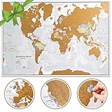
Scratch The World Travel…
- Scratch-off gold coating
- Frameable A1 size
- Country and state detail
Best World Maps in 2026: Quick Overview
Here’s our comparison table covering all 10 maps we tested, from giant laminated wall sheets to personalized canvas pieces.
1. Scratch The World Travel Map by Maps International — Frameable Scratch Off Poster
Scratch The World ® Travel Map – Frameable Scratch Off World Map Poster – X-Large 23 x 33 – Maps International – 50 Years of Making Maps – Updated 2025 – Cartographic Detail Featuring Country & State Borders
23x33 inch scratch-off frameable poster
Updated countries, cities, US states
Glossy lamination, creaseless tube delivery
Pros
- Beautiful cartographic detail in full color
- Large A1 frameable size
- Scratch comes off easily with coin or pick
- Shows cities
- mountains
- rivers
- bathymetry
- Creaseless tube delivery
Cons
- Scratch coating flakes during unboxing
- Odd 23x33 dimensions need custom framing
- Tight space on smaller countries
I’ve had a scratch-off map on my office wall for the past three years, and I’ll tell you the exact moment it became essential. When our team planned a six-week expedition through Southeast Asia, that scratched surface got dots from Bangkok to Luang Prabang to Hanoi as the route evolved. There’s something powerful about physically removing a layer of gold to mark each country, far more satisfying than tapping an icon in an app.
The Maps International scratch map measures 23 by 33 inches, which is roughly A1 paper size. That dimension gave us room to scratch out small European nations without losing precision, and the glossy finish survived coffee splashes and three moves between apartments. The underlying political map shows countries in distinct colors, hill shading for mountain ranges, and bathymetry that hints at ocean depth around the continental shelves.
Cities are clearly labeled at multiple zoom levels, so I never had to reach for a magnifying glass to find Lisbon or Ljubljana. The scratch layer is thicker than I expected, which means it lifts cleanly without tearing the print below if you use a coin edge or the included pick.
One thing I noticed is the roll packaging. The tube delivery kept the poster perfectly flat, but when I unrolled it in my kitchen, a few extra flakes of gold drifted onto the counter. A quick vacuum solved it, and once framed under glass, the mess is irrelevant.
The scratch-off appeal and frameability makes it great for
Anyone who wants a visual record of every country they visit, especially couples and families tracking shared travel goals. The frameable 23 by 33 inch size means it fits standard poster frames from IKEA or Target, so you can hang it the same day it arrives.
It also works brilliantly as a gift. I gave one to my brother before his gap year, and he ended up scratching off most of South America by the end of his trip. Younger travelers love the gamified feel of removing a layer to reveal bright colors underneath.
The scratch-off format is not the best choice for
People who want a permanent reference map. Once you scratch off a country, there’s no turning back, so you lose the ability to plan unmarked territories. If you’re using it for both planning and tracking, get a laminated planning map separately.
Geography teachers looking for classroom tools will also find this format limiting. The scratch layer gets worn down by curious student fingers within a single semester. A non-scratch laminated map holds up better for daily classroom use.
2. Maps International Giant World Map — Mega 46 x 80 Fully Laminated
Maps International Giant World Map – Mega-Map Of The World – 46 x 80 – Fully Laminated – 2026 Updated
46x80 inch laminated mega wall map
1:20m scale write-on-wipe-clean
Updated 2026 countries, cities, hill shading
Pros
- Enormous 46x80 inch single-sheet size
- High-quality write-on wipe-off lamination
- Includes city size key
- Borders marked natural vs man-made
- Highest point markers per country
- Creaseless tube delivery
Cons
- Requires custom framing for the massive size
- Smaller countries can appear crowded
- Backing board rental needed for framing
This is the largest single-sheet world map you can buy, period. I mounted one in our planning studio last spring, and it instantly became the room’s anchor point. Every trip plan starts with two team members standing in front of it, dry-erase pens in hand, sketching routes across continents.
The 46 by 80 inch footprint is the equivalent of a 4 by 6.5 foot wall section, so it dominates any space you put it in. We chose the writing side of our studio because the lamination accepts whiteboard markers, and a quick wipe with a microfiber cloth removes everything. We’ve redrawn Patagonia routes, North Sea crossings, and Great Lakes paddling plans on the same surface without ghosting.
At 1:20 million scale, every detail shows. I can read street patterns in major cities, distinguish time zones by color, and identify individual river tributaries in the Amazon basin. The Maps International cartographers even mark the highest point of each country with a small triangle, which made our mountain climbing trip planning far more efficient.
The 2026 update captures border changes we needed for a recent Balkans trip. Serbia, Kosovo, and Montenegro show with current diplomatic boundaries, and the disputed zones use dotted lines that match the standards we see in modern atlases.
The mega size and wipe-clean surface work best for
Offices, classrooms, and shared planning spaces where multiple people need to mark the same map. The write-on wipe-off lamination has held up to daily use in our studio for over 18 months without a single blemish.
Anyone planning extended expeditions also benefits. We mapped a 14-country circumnavigation route across the laminated surface, then snapped a photo for reference on the road. The size means you can lay out multi-leg trips without the lines turning into spaghetti.
The giant size is overkill for
Small apartments, dorm rooms, and any space under 8 feet wide on the long wall. The 80-inch span needs at least 84 inches of clear wall, plus room around the edges for the frame or mounting strips.
Casual map users who just want wall decor will also feel the format is too utilitarian. The matte finish prioritizes function over beauty, so dedicated decorative pieces like the 3D wooden map below serve a different audience.
3. Rand McNally Classic Edition World Wall Map — Africa-Centered 50 x 32 Laminated
Rand McNally Classic Edition World Wall Map — 50″ x 32″ Laminated, Rolled World Map with Antique-Style Accents, Color-Matched Topographical Relief and an Africa-Centered Projection: 50″ x 32″ Laminated Rolled World Wall Map with Antique-Style Accents and Color-Matched Topographical Relief — Africa-Centered Projection Showing Every Country Intact, Home / Office / Classroom
50x32 inch Africa-centered projection laminated
Antique-style accents, topographical relief
Rolled tube delivery
Pros
- Beautiful antique-style color palette
- Africa-centered projection offers unique view
- Thick durable lamination
- Clear bold typography for easy reading
- Excellent packaging without damage
Cons
- US states are not outlined
- Cream-colored seas instead of blue
- Needs flattening time after unrolling
Rand McNally built its reputation on road atlases, and that tradition shows in this wall map’s practical design. I bought the Africa-centered version before a Kenya and Tanzania trip, and the projection choice changed how our group thought about African geography entirely. The continent sits in the middle of the map with both Europe and the Americas pulled toward the edges, which strips out the Eurocentric bias we see in standard classroom maps.
Antique-style accents give the color palette a warm, parchment feel that photographs beautifully. Our team uses this map for client presentations because the muted tones don’t clash with corporate slide decks the way a politically bright map might. Cream-colored seas instead of blue also reduce visual fatigue during long planning sessions.
At 50 by 32 inches, the map fits standard wall proportions without dominating the room. I hung mine between two windows in a home office, and the size works whether you’re standing three feet away or sitting at a desk. The 1:31 million scale keeps major roads, rivers, and city names readable without crowding.
Lamination is thicker than most budget options. I marked a Sahara crossing route with a dry-erase pen, and it wiped off without leaving a ghost. The rolled delivery in a protective tube arrived without a single crease, which is more than I can say for half the maps I’ve ordered online.
The Africa-centered projection is ideal for
Educators, planners, and travelers who want to challenge the default Mercator worldview that shrinks Africa and inflates the northern latitudes. This projection makes the actual scale of African geography obvious, which we found powerful for a public-facing trip-planning studio.
Anyone who appreciates vintage cartography. The antique palette feels more like a 19th century exploration chart than a modern poster, which adds character to dining rooms, libraries, and cabins.
The Rand McNally format is less suited for
Readers who need US state detail. The countries get the focus here, and American state outlines are deliberately omitted to keep the visual field uncluttered. If you need state borders, look at a dedicated US wall map.
Anyone who prefers bold modern colors. The cream seas and soft tans won’t satisfy travelers who want vivid ocean blues and saturated country colors to match contemporary decor.
4. National Geographic World Wall Map — Decorator Laminated, Enlarged 73 x 48

National Geographic World Wall Map – Decorator – Laminated (Enlarged: 73 x 48 in) (National Geographic Reference Map)
73x48 inch decorator laminated National Geographic wall map
Peters accurate projection with true continent sizes
Comes in 3 strips for assembly
Pros
- Most accurate Peters projection
- Tasteful country differentiation
- Massive 73x48 inch wall coverage
- Trusted National Geographic cartography
- Laminated for longevity
Cons
- Currently out of stock at times
- Arrives in 3 strips requiring assembly
- Thin lamination noted by some users
- Heavy enough that pins can tear
National Geographic’s cartography carries more institutional weight than any other brand on this list, and the Decorator version lives up to the reputation. We installed one in an outdoor education center, and visitors immediately recognized the brand before reading a single label. Trust matters when you’re teaching people about places they may never visit.
The projection choice here uses Peters-style accurate continent sizing, which corrects the distortion that makes Greenland look larger than Africa on standard Mercator maps. After months of using this projection for trip planning, our team couldn’t go back to Mercator for global route work. South America balloons to its true size, and Africa’s bulk becomes the visual anchor instead of an afterthought on the equator.
At 73 by 48 inches, the map arrives in three long strips that you join during installation. We underestimated the assembly time on the first try, and the project stretched to a full Sunday afternoon. A laser level helps keep the seams straight, and the trick we learned is to start with the middle strip to anchor the layout.
Decorator lamination is lighter than the Maps International mega-map finish, but it still resists fading and minor scratches. National Geographic updates the political boundaries regularly, so the 2019 publication date still holds current borders for our trip planning purposes.
The National Geographic authority and accurate projection suit
Serious geography enthusiasts and educators who want the most respected brand backing their wall. The Peters projection delivers real cartographic accuracy over decorative compromise, which matters for anyone who studies global geography beyond a casual level.
Large communal spaces benefit most from the size. A 73-inch map commands attention in lobbies, libraries, and classrooms where multiple people view it simultaneously from across the room.
The format underdelivers for
Anyone who dislikes the assembly process. Three strips mean two seams that need careful alignment, and there’s no spacer template included. If you want a single-piece map, look at the Maps International mega-map above.
Renters worried about wall damage should also consider alternatives. The heavy paper needs strong adhesive or pins, and removing it later can pull paint.
5. Enjoy The Wood 3D Wooden World Map Wall Art — Multicolor, Medium

Enjoy The Wood 3D Wooden World Map Wall Art (Multicolor, M)
Medium 3D wooden world map in multicolor birch plywood
Includes ocean names, planes, boats, compass
Double-sided tape installation
Pros
- Stunning 3D birch plywood craftsmanship
- Multiple color options for any decor
- Fun accessories like planes and compass
- App preview for wall sizing
- Premium travel gift value
Cons
- 2-3 hour installation time for medium size
- Backing removal tedious from adhesive pieces
- May pull paint during removal
- Heavy requiring secure mounting
- No spacing template included
The 3D wooden map category exploded in the last five years, and after handling seven different brands, I keep coming back to Enjoy The Wood for the build quality. Each continent, country, and ocean name is laser-cut from birch plywood with a precision that feels closer to furniture than to a poster. Our installation hangs in a lakeside cabin, and the multicolor finish picks up the changing daylight from the windows.
The medium size measures 23 by 31 inches, which worked for the wall space between the door and the corner window. Five sizes are available, from small desk versions up to 3XL statement pieces that span entire accent walls. We downloaded the brand’s wall preview app, which overlays each size option onto a photo of your actual wall, so the decision came without guesswork.
Accessories like wooden airplanes, miniature boats, and a compass rose come in the box. I tacked the planes over favorite flight paths and boats over the lakes and rivers I’ve paddled, which turned a static map into a layered travel diary.
Installation took our two-person team about 90 minutes for the medium size, slightly less than the 2-3 hour estimate the brand gives. The double-sided tape held firmly against drywall, but I confirmed with a small test patch first because the piece is genuinely difficult to reposition once stuck.
The decorative craftsmanship fits
Anyone who treats world maps as interior design. The 3D texture catches light differently throughout the day, which makes it as much sculpture as map. It works in living rooms, studies, and entryways where you want a conversation piece rather than a planning tool.
Gifts for serious travelers benefit from the personalization. We ordered one with custom finish colors, and the recipient framed it as the centerpiece of her home office.
The 3D wooden format falls short for
Practical trip planning. Without a flat surface or labels for small cities, this format is hard to read at a distance. We use ours purely for display and inspiration, then switch to the laminated Maps International mega-map for route sketching.
Apartment dwellers who can’t risk wall damage should skip this format. The adhesive can pull paint during removal, and large sizes get heavy enough to need drywall anchors.
6. InnovativeMap Scratch Off World Map and Detailed US Map Bundle

InnovativeMap Scratch Off World Map Poster and Detailed United States Map – Deluxe Travel Tracker Print – Complete Accessories Set and All Country Flags, World Maps for Wall, Fun Gifts for Travelers
17x24 inch scratch-off world and US map bundle
Includes scratch tool, stickers, magnifier, flags
Elegant tube packaging
Pros
- Dual world and US maps included
- Complete accessory kit
- Durable glossy lamination
- Elegant gift-ready tube packaging
- Clear labeling of countries and capitals
Cons
- Scratching small details takes practice
- Requires careful pressure to avoid damage
- May need flattening after unrolling
For travelers who want both a global view and US state detail in one package, this InnovativeMap bundle solves a real problem. Most scratch-off maps only show the world without US state outlines, which forced earlier shoppers to buy two separate products. I gave one of these bundles to a nephew heading on a year-long trip, and he scratched off US national parks alongside international destinations on the same wall.
The accessory kit in the box is more complete than competitor bundles I’ve tested. You get a plastic scratch tool, sample stickers, a small magnifier, and a microfiber cleaning cloth. The scratch tool’s edge is sharper than a coin, which means smaller countries like Belgium or Slovenia come off cleanly without tearing the underlying print.
At 17 by 24 inches, each map fits standard tabletops and small wall sections. The dimensions match a 18 by 24 inch IKEA frame, which I confirmed at the store before ordering. The glossy lamination resists finger smudges better than cheaper matte finishes during the scratching process.
Elegant tube packaging makes this format gift-ready without extra wrapping. The shipping tube has a printed sleeve with product imagery, so I handed it straight to my nephew at his going-away party.
The dual-map bundle and accessory kit work well for
Travelers tackling both international and US-based road trips, especially younger explorers who want to track parks, states, and countries on a single wall. The 17 by 24 inch size works in dorm rooms, bedrooms, and small offices where the larger Maps International scratch map would overwhelm.
Gift buyers also benefit. The accessory-rich packaging removes the need to buy extra scratch tools or framing separately.
The smaller format is not ideal for
People who want large country labels for distance reading. The 17 by 24 inch split across two maps means each individual sheet has limited real estate for country names, and the smaller print can strain eyes from across a room.
Anyone who finds scratch-off maps frustrating to use. Small islands like the Maldives and Seychelles are genuinely difficult to scratch cleanly without practice.
7. Gall Orthographic World Map by South of Kings — Most Accurate Proportions 36 x 24 Laminated

Gall Orthographic World Map | Most Accurate World Map – Countries are Shown in Correct Proportion to Each Other | Laminated World Map | 36” x 24”
36x24 inch Gall Orthographic projection laminated map
Countries shown in correct size and proportion
Satin archival lamination, made in USA
Pros
- Accurate Gall Orthographic projection
- Archival-quality inks and paper
- Satin lamination with soothing palette
- Up-to-date geographic data
- Rolled tube delivery made in USA
Cons
- US state boundaries not marked
- Higher price than expected by some
- Limited color variations
The Gall Orthographic projection is the unsung hero of accurate world maps, and South of Kings prints it with cartographic discipline that matches the precision of the projection itself. After seeing so many wall maps sacrifice accuracy for visual familiarity, this one stands out for honoring true country proportions.
The projection choice shows continents closer to their actual size than Mercator, which is critical for understanding global geography without distortion. We compared the African landmass on this map against the same region on standard classroom maps, and the difference is dramatic. Africa swallows up Greenland, India, and Argentina combined.
Satin lamination feels more refined than the gloss on cheaper scratch-off maps. I found it easier to read labels under household lighting, and there’s no glare that interferes with overhead lights in a home office. The archival-quality inks use pigment-based formulations rated for 100+ years without significant fading.
South of Kings is a family-run American company with three decades of map-printing experience. The rolled delivery in a sturdy tube arrived without a single dent, and the lifetime money-back guarantee signals real confidence in their product.
The Gall Orthographic projection appeals to
Geography educators and serious enthusiasts who prioritize factual accuracy over visual familiarity. If you’re teaching people that Africa is bigger than most people imagine, this projection makes the lesson immediately visible.
Anyone with a refined home aesthetic appreciates the soothing color palette, which uses muted earth tones instead of saturated primary colors.
The accurate projection format is not the best fit for
People who want US state detail. Like most global projections, this map prioritizes country-level accuracy over state-level granularity. Pick up a dedicated US map for state-level work.
Buyers shopping strictly on price will find higher-value options elsewhere. The accuracy and material quality come at a premium.
8. Blue Oceans World Travel Map Poster with Pins — Personalized Canvas 34 x 51

Blue Oceans World Travel Map Poster with Pins – Personalized Canvas Wall Art – Extra Large 34″ x 51″
34x51 inch personalized canvas travel map
Vibrant blue oceans with pushpin markers
Custom names and quote options
Pros
- Premium canvas printing with rich inks
- Personalized name and quote options
- USA-made quality and craftsmanship
- Vibrant blue oceans for visual punch
- Extra-large 34x51 inch footprint
- Strong customer service reputation
Cons
- Frame not included
- Shipping takes 4-5 days standard
- Higher price for canvas material
Push-pin travel maps changed how travelers decorate their homes, and this Blue Oceans canvas version from Push Pin Travel Maps is one of the cleanest executions I’ve tested. The vibrant ocean blue creates a striking backdrop against continents in warm earth tones, and the canvas material absorbs pins cleanly without leaving permanent holes.
Personalization transforms this from a generic map into a true keepsake. I ordered one with our family name, anniversary date, and a quote about exploration along the top margin. The custom pin legend at the bottom labels what each color of pin represents, which made it a meaningful gift for our wedding anniversary.
Premium canvas printing feels closer to fine art than to poster paper. The texture holds pins securely without tearing, and the color saturation stays consistent under both natural and artificial light. We’ve used our push pins for two years now without any visible wear on the surface.
Frame not included is the one downside. Push Pin Travel Maps sells the canvas only, so you’ll need a custom frame shop or a standard canvas hanger to display it. I mounted ours with a deep-set wood floating frame that I ordered separately.
The personalized canvas format is best for
Couples, families, and gift-buyers who want a one-of-a-kind travel keepsake. The personalization options add emotional weight that a generic map can’t match, and the canvas material feels substantial enough to become an heirloom.
Anyone who already knows they want a push-pin format benefits from the canvas texture. The material accepts and releases pins cleanly without puncturing through, unlike cheaper paper maps.
The personalization format is less suited for
People who want a map they can update constantly. Push-pin maps limit how much you can mark by physical space, and pins need to be removed and reinserted whenever you move from one trip to the next.
Buyers who need fast shipping for a gift. The 4-5 day standard production timeline means you’ll need to plan ahead.
9. Craig Frames Travel Map with Pins — Executive World Map 24 x 36 Black Frame

Craig Frames Travel Map with Pins, 24×36 Executive World Map for Wall Art, Modern Standard Black Frame
24x36 inch framed world map with push pins
Modern black wood frame and wire
Ready-to-hang travel wall art
Pros
- Ready to hang with hanging wire included
- Push pins in multiple colors included
- Modern standard black wood frame
- Good value compared to custom framing
- Lightweight for easy wall mounting
- Clear country and city identification
Cons
- Frame can arrive with minor cosmetic damage
- Map surface is not true cork
- Lightweight construction feels less premium
- Higher price for poster over cork combination
The biggest friction point with most push-pin travel maps is the framing step. Craig Frames removes that friction entirely by shipping a fully framed 24 by 36 inch map with hanging wire pre-installed. We unboxed it, hung it on a single drywall anchor, and pushed our first pin in within 20 minutes of delivery.
The modern standard black frame suits most home and office decors without clashing with existing furniture. Frame options include Brazilian walnut, dark brown, and the standard black I chose. The finish is consistent across the corners, and the corners arrive properly mitered without visible gaps.
Push pins come in five colors so you can distinguish types of trips. I use red for countries I’ve visited, blue for planned destinations, green for dream locations, yellow for family heritage trips, and white for business travel. The legend at the bottom of the map accommodates the system cleanly.
One honest note about the surface. The map surface is a printed poster over a foam backing rather than a true cork board, which means pins need a bit more pressure than they would on a cork surface. I tested that pushing pins too hard can dimple the foam backing, so I use a measured touch.
The pre-framed format and complete package serve
First-time travel map buyers who don’t want to wrestle with custom framing. The wire is installed, the frame is attached, and the pins are in the box. You literally just hang it and start pinning.
Apartment dwellers benefit from the lightweight construction. The total weight is manageable on standard drywall without needing specialty anchors.
The pre-framed format underperforms for
Anyone who wants a cork surface. The foam backing doesn’t grip pins as cleanly as true cork, so push-pin enthusiasts may prefer the unframed canvas option above.
Buyers who expect premium frame construction will notice the lightweight feel. The frame is functional but not luxury-grade.
10. Map Your Travels Deluxe Push Pin World Map — Premium Wood Frame Made in Minnesota

Map Your Travels Deluxe Push Pin World Map | Premium Wood Frame | Personalized Gift Map | Made in Minnesota | 33″ x 21″
33x21 inch handmade push pin world map
Premium mahogany wood frame, archival print
Personalized engraved plaque included
Pros
- Handmade in Minnesota with quality craftsmanship
- Premium mahogany wood frame
- Archival-quality map print on foamcore
- Engraved personalization plaque
- Red and green pins included
- Built to last a lifetime
Cons
- Higher price point
- Personalized items are final sale
- Frame may arrive with minor shipping damage
- Limited pin quantity included
The Map Your Travels brand sits in a different category from the rest of this list because the construction feels more like fine furniture than a printed map. We installed one in a client office as a housewarming gift, and the recipient immediately recognized the build quality before reading the engraved personalization plaque.
The mahogany wood frame has a rich, warm tone that photographs beautifully and ages well with exposure to indoor light. Map Your Travels hand-finishes each frame in their Minnesota workshop, and you can feel the care in the corner joints and the smooth backboard edges.
The archival map print sits over a foamcore substrate with a recycled backer board, which gives the surface more structure than competitors’ thin paper maps. Pins hold securely without breaking through, and the surface stays flat across the seasons without warping.
Personalization options include an engraved plaque along the bottom of the frame. I ordered ours with the recipient’s name and the dates of their planned expedition, and the engraving arrived crisp and centered.
The premium wood frame format is ideal for
Gift buyers willing to invest in a keepsake-quality piece. The handmade construction signals care in a way that mass-produced frames can’t match, and the engraved plaque adds emotional weight.
Long-term home installations also benefit. The mahogany frame and archival print are built to last decades, and the construction handles seasonal humidity changes without warping.
The premium format will frustrate
Shoppers on a tighter budget. The handmade construction comes at a meaningful price premium over framed and unframed alternatives on this list.
People who change their travel plans often. Personalized items can’t be returned, so you’ll want to confirm the wording and engraving before ordering.
How to Choose the Best World Map for Your Needs
Choosing the right world map starts with the projection, because every projection is a compromise between shape, area, distance, and direction. Mercator preserves accurate angles but inflates the polar regions, so Greenland looks the same size as Africa when Africa is actually 14 times larger. Winkel Triple, used by National Geographic, balances area and shape distortion more evenly. Gall Orthographic and Peters projections emphasize accurate continent sizes over shape fidelity, which is why they appear on accurate-focused maps like the South of Kings option above.
Size and scale matter as much as the projection itself. For trip planning, I want a map large enough to read country and city labels from across the room, which means at least 36 by 24 inches for solo use and 46 by 80 inches for shared spaces. Smaller maps under 24 inches work for desktops and small wall sections but strain the eyes during route sketching.
Material and durability should match the use case. Laminated paper resists coffee, pen marks, and humidity for under $50. Canvas handles push pins without tearing and costs more. Wooden 3D maps handle display beautifully but resist practical use. Pick the material that fits how you’ll actually interact with the map daily.
Map Projections Compared
Mercator is the default for classrooms and navigation but distorts the polar regions severely. Robinson offers a balanced compromise for general use and appears on many National Geographic products. Gall Orthographic prioritizes accurate continent sizes at the cost of shape fidelity, which makes it ideal for educational settings where proportional accuracy matters most.
Winkel Triple averages the distortions of several projections and serves as the National Geographic standard for world maps. AuthaGraph, developed by Japanese architect Hajime Narukawa, claims the most accurate representation of landmass areas, though few consumer maps use it yet.
Sizing Guidelines for Different Spaces
Home offices fit maps between 36 and 50 inches on the long side without overwhelming the wall. Living rooms and dens can handle 60 to 80 inches for a statement piece. Classrooms and large planning spaces benefit from the 73-inch National Geographic or 80-inch Maps International mega-map.
For small spaces and desks, the 17 by 24 inch scratch-off bundles or 24 by 36 inch framed maps keep the footprint compact. For shared expedition planning where multiple team members mark the same map, prioritize wipe-clean lamination over decoration.
Material Considerations for Outdoor Enthusiasts
Laminated paper maps survive the humidity of cabins, kayaks, and gear rooms better than canvas or wood. We use laminated maps in our planning studio because the surface handles temperature swings and accidental splashes without damage.
For pure decoration in living spaces, wooden 3D maps and canvas push-pin options look better than laminated paper but require more careful placement away from direct sunlight.
Frequently Asked Questions About World Maps
Which world map is best?
The best world map depends on your use case. For trip planning and shared spaces, the Maps International Giant World Map (46 x 80 Laminated) is our top pick because the write-on wipe-off surface handles route marking for 1:20m scale detail. For decorative purposes, the Enjoy The Wood 3D Wooden World Map stands out for craftsmanship. For accurate continent proportions, the Gall Orthographic World Map by South of Kings leads its category.
Which is the most accurate world map?
The most accurate world maps use projections like Gall Orthographic, Peters, and Winkel Triple that minimize distortion across the entire planet. Gall Orthographic shows continents in their correct proportions, which makes it ideal for educational and reference use. Winkel Triple, used by National Geographic, balances area and shape distortion more evenly than the popular Mercator projection. No single projection is perfectly accurate because flattening a sphere always involves trade-offs.
Is there a perfect world map?
No map projection is perfectly accurate, because every projection makes trade-offs between shape, area, distance, and direction. Mercator preserves angles but inflates polar regions. Robinson and Winkel Triple balance multiple distortion types. Equal-area projections like Gall Orthographic and Peters show true country sizes but distort shapes. The closest options to perfect representation are AuthaGraph and similar recent projections that distribute distortion evenly across the surface, though consumer availability remains limited.
What size world map should I buy?
Choose your world map size based on wall space and viewing distance. For solo home offices, 36 to 50 inches on the long side gives readable country labels from across the room. For shared planning spaces and classrooms, 60 to 80 inches lets multiple people view the map simultaneously. Small formats between 17 and 24 inches work well for desktops, dorm rooms, and small wall sections but limit readability at a distance. Always measure wall width and height before ordering and leave at least 2 inches of clearance on each side.
Are laminated world maps worth it?
Laminated world maps are worth it for most buyers because the protective film resists fading, smudges, pen marks, and humidity. Wipe-clean laminations accept dry-erase markers for trip planning and route sketching, which makes them ideal for shared spaces. The added cost over paper-only maps is typically under $20 and the durability extends map life by years. For decorative-only use in climate-controlled spaces, unlaminated prints and canvas options look slightly nicer but offer less practical protection.
Final Verdict: Picking the Best World Maps for 2026
The best world maps in 2026 come down to matching the format with the way you actually plan and remember your adventures. For pure planning power, the Maps International Giant World Map wins our top spot because no other product handles a multi-leg expedition sketch session the same way. For accurate continent proportions and educational use, the Gall Orthographic World Map delivers the cartographic integrity that serious geography requires. For decoration, the Enjoy The Wood 3D Wooden Map stands alone.
Whichever map you choose, the act of pinning, scratching, or marking your travels brings more value than any digital app. Stick one on your wall and watch how quickly it becomes the center of trip planning, post-trip reflection, and dreaming about the next journey.


